Routecard The Twelve Bens

Routecard The Twelve Bens
Updated March 2015 Jim Holmes
BACK TO CHALLENGE WALK CALENDAR
1. Inagh Valley IL 84483 49559 41 m
2. Nature Reserve Track IL 83155 50637 80 m
3. Derryclare Way IL 82835 51069 266 m
4. Derryclare Ridge IL 82451 51122 436 m
5. Derryclare IL 81480 51082 673 m
6. Bencorr Way IL 81240 51705 550 m
7. Bencorr IL 81148 52193 711 m
8. Saighdiúra IL 81169 52864 653 m
9. Bencorrbeg IL 81600 53301 577 m
10. Saighdiúra IL 81169 52864 653 m
11. Mám na bhFonsai IL 80593 52439 494 m
12. Binn Dhubh Ridge IL 80068 52798 635 m
13. Bencollaghduff IL 79800 53001 696 m
14. Maumina Ridge IL 79154 52977 563 m
15. Maumderg IL 78825 52749 457 m
16. Beanna Beola Way IL 78583 52268 656 m
17. Beanna Beola Ridge IL 78104 51992 680 m
18. Benbreen IL 78307 51551 691 m
19. Glengower IL 78223 51114 466 m
20. Bengower IL 78315 50648 664 m
21. Douglas Ridge IL 77749 50220 550 m
22. Benlettery IL 77537 49542 577 m
23. Uisce Saddle IL 77294 50299 469 m
24. Benglenisky IL 76619 50109 516 m
25. Glenisky Ridge IL 77152 50762 375 m
26. Breen Run IL 77612 51236 270 m
27. Tievebreen IL 77362 51584 269 m
28. Beanna Beola Run IL 77488 52263 269 m
29. Barnanang Ridge IL 78098 52683 372 m
30. Maumina IL 78814 53147 414 m
31. Binn Bhán Way IL 78568 53549 550 m
32. Benbaun IL 78557 53921 729 m
33. Binn Bhán Ridge IL 78301 54230 649 m
34. Tairbh Way IL 77919 54337 591 m
35. Benfree IL 77744 54414 638 m
36. Tairbh Saddle IL 77316 54208 472 m
37. Muckanaght IL 76772 54088 654 m
38. An Chailleach Way IL 76186 54021 475 m
39. Bencullagh IL 75558 53726 632 m
40. An Chailleach Ridge IL 75228 53865 547 m
41. Maumonght IL 74781 54182 580 m
42. River Bridge IL 74036 55721 152 m
43. Addergoole IL 73233 56718 297 m
44. Diamond Hill IL 73145 57046 439 m
45. Bards Den agus Pints IL 70984 57780 40 m
N.B. Always remember that whilst GPS is an exellent tool it should never be substituted for competent navigational skills. Many of the above waypoints have been amassed by myself over the years and named by using their closest features on various accepted maps, but may not be the best given route that the day may dictate. In good visibility your walking route will be a whole lot more obvious and arc and flow neatly. However in thick mist (or even snow storms) the above waypoints are where I personally feel I need to be so as to keep safe and sound. It is important to note however that at times the route between two waypoints may be more of an arc than a straight line.
This was the great Challenge Walk that was! It was last hosted by Na Beanna Beola Hillwalking Club in 2007 and was made possible (by no small means) with the help of local land-owners.
It is a tough, tough walk (and that's in fine weather!).
The walk first bests Binn Doire Chlair (Derryclare) and then follows a horseshoe around to Benlettery and then to Benglenisky.
From here it a piece of tricky navigation (lonely, let alone dangerous in white-out) to "contour" along the ridge passing Tievebreen around to Maumina before the mighty Binn Bhán (Benbaun) beckons.
The last part of the Challenge Walk (from River Bridge onwards) passes through private farmland - so of course any said permissions would natually be required.
As with all Challenge Walks one should always ensure to have their "homework" done so as to allow for a safe enjoyable day. . . After all . . . . "accidents don't happen by accident".
Keep Safe and enjoy your day!
Jim Holmes.
BACK TO CHALLENGE WALK CALENDAR
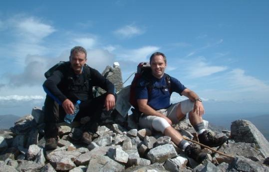
Famous, or rather infamous, photo below is of "Fat Boy" Eddie McBride and "Fat 2" Jim Holmes atop Binn Bhán on The Twelve Bens Challenge 2007, a day that saw perfect weather!