Members and Supporters, the MountainViews Committee requests your help to meet the costs of the website and of other activities such as insured events or publications.
Feature count in area: 29, all in Kerry,
OSI/LPS Maps: 78, EW-KNP, EW-R
Highest Place: Carrauntoohil 1038.6m
Starting Places (19) in area MacGillycuddy's Reeks: Ballaghbeama Gap, Bridia Valley End, Cronins Yard, Gap of Dunloe Head of, Gap of Dunloe Kate K, Glashaknockbrassel Stream, Glasheenoultagh Stream, Hydro Road CP, Knocknsallagh Bridge, Lisleibane Trail Head, Lough Acoose North, Lough Acoose West, Lough Cappanlea OEC, Lough Caragh SW, Lough Fada N, Lough Reagh N, Maghanlawaun Bridia Valley, Shamrock Farmhouse B&B, Tomies Lough Leane NW
Summits & other features in area MacGillycuddy's Reeks: Cen: Reeks West: Beenkeragh 1008.2m, Caher 1000m, Caher West Top 973.4m, Carrauntoohil 1038.6m, Cnoc Íochtair 746.3m, Hag's Tooth 662m, Knockbrinnea East Top 845.4m, Knockbrinnea West Top 852.2m, The Bones Peak 956.5m, Skregmore 847.7m, Stumpa Bharr na hAbhann 852.1m E: Cnoc an Bhráca: Cnoc an Bhráca 728m, Cnoc na dTarbh 655m, Strickeen 440m N: Reeks North: Knockbrack 425m, Knocknabrone Hill 353m, Skregbeg 573m NW: Gortnagan: Gortnagan Beg 298m SE: Reeks East: Brassel Mountain 575m, Cnoc an Chuillinn 954.6m, Cnoc an Chuillinn East Top 922.9m, Knocknapeasta 985.1m, Cnoc na Toinne 844.1m, Cruach Mhór 930.8m, Maolán Buí 968.9m, The Big Gun 939.9m SW: Bridia: Beann Bhán 459.5m, Beendarrig 449.7m, Beann Dubh 450.5m
Note: this list of places may include island features such as summits, but not
islands as such.
Knocknabrone Hill, 353mHill Cnoc na Brón A name in Irish,
Place Rating ..
Derryfanga an extra name in English, Kerry County in Munster province, in Binnion Lists, Knocknabrone Hill is the 1055th highest place in Ireland.
Grid Reference V75712 86812,
OS 1:50k mapsheet 78 Place visited by: 19members, recently by: eamonoc, John.geary, chelman7, Taisce, Wilderness, Fergalh, finkey86, markmjcampion, ciarraioch, Cobhclimber, trekker, frankmc04, chalky, turfymccloud, simon3
I visited this place: NO (You need to be a logged-in member for this.)
Longitude: -9.811252, Latitude: 52.019904, Easting: 75712, Northing: 86812,
Prominence: 188m, Isolation: 2.9km ITM: 475689 586871 Bedrock type: Well-bedded grey sandstone, (Lough Acoose Sandstone Formation) Notes on name: Ó Cíobháin suggests that this name may be a corruption of Doire na Féinne, a nearby townland. It is otherwise difficult to explain.
Short or GPS IDs, 6 char: Knc353, 10 char: KncknbrHil Linkback: https://mountainviews.ie/summit/899/
Gallery for Knocknabrone Hill (Cnoc na Brón) and surrounds
Summary
for Knocknabrone Hill (Cnoc na Brón):
Rough ground, great views, shortish walk.
Summary created by simon3
2012-07-14 07:28:11
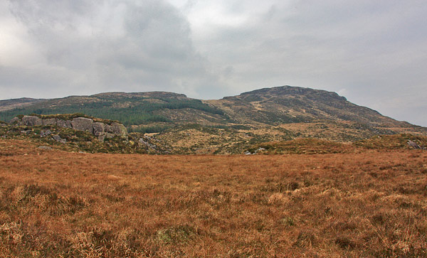
Picture: Knocknabrone from the South.
This is a hill isolated by roads and properties and makes for a short though somewhat rough up and down walk. Walking in a dry period would be preferable though not essential.
One place to start is from the road near Lough Acoose on which there is a small amount of parking. Find a way onto the hillside such as the animal track at A (V75442 85617). Access may also be possible from the B&Bs around B (V7718 8743)
There is a spot height of 228 on a rocky bump and either side is equally good or bad. Generally, follow the east edge of the forestry plantations, using the numerous sheep tracks as there is no walking path through the occasionally dense furze. The top is around 1200m away which will take aournd 40 mins to reach and about 30 to return.
Note that the apparent minor road on the OS map leading north from L. Acoose is in reality a forest track festooned with an Ireland of the Unwelcomes sign.
The rewards for such a small hill are considerable. There is a huge view of the Reeks, the Iveragh penisula and even parts of Dingle.
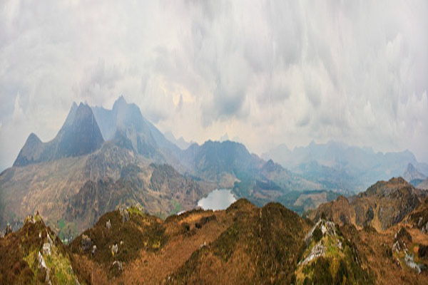
It's hard to do justice with the extent of the view in any photograph, particularly from a dull day, of the enormous 220 degree panorama that Knocknabrone enjoys, but we can at least have some fun with it.
MountainViews presents the impressionist version of the Iveragh peninsula from Reeks to the left and Seefin of the Glenbeigh Horseshoe on the right. Added bonus feature: Sky Angst Linkback: mountainviews.ie/summit/899/comment/6750/
Read Less
Read More
HoschIchenheim on Knocknabrone Hill
by HoschIchenheim
5 Dec 2008
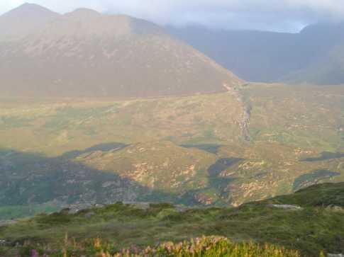
Derryfanga despite being a low hill can offer magnificent views to Dingle Bay and Peninsula, a view not too much different from the bigger hills of the adjacent Reeks area. Good weather provided, you can also see all the peaks of Coomloughra horseshoe (Caher Tops, Carrauntuohil, Beenkeragh, Skregmore etc.) as well as the route up to Caher West Top. Particularly nice to be seen from there is Skregbeg, though I have no photo of it. My son and myself coming all the way from Germany went "up" Derryfanga on 3rd and 4th of September, 2005 while staying at Sheila Doona's Lakeview B&B near Lough Acoose. From there it takes only 10 to 15 minutes to reach the top. So in case you miss the high peaks due to bad weather, but have some short period of good weather on that same day it is rewarding to take the short walk up Derryfanga. Linkback: mountainviews.ie/summit/899/comment/3466/
Use of MountainViews is governed by conditions and a privacy policy.
Read general information about the site. Opinions in material here are not necessarily endorsed by MountainViews.
Hillwalking is a risk sport. Information in comments, walks, shared GPS tracks or about starting places may
not be accurate for example as regards safety or access permission. You are responsible for your safety and your permission to walk.
See the credits and list definitions.


 Our Facebook page.