Donation Request 2024

DONATE
Members and Supporters, the MountainViews Committee requests your help to meet the costs of the website and of other activities such as insured events or publications.
You do not have to be logged in to donate.
Features
Nearby features appear when you click the map.
Declutter tracks on map.
Place Search
Video
X
Pub: by
Knockmealdown Mountains Area , Cen: Central Knockmealdowns Subarea
Feature count in area: 17, by county: Tipperary: 11, Waterford: 11, of which 5 are in both Tipperary and Waterford, OSI/LPS Maps: 74, 82, EW-K
Highest Place: Knockmealdown 792.4m

Starting Places (16) in area Knockmealdown Mountains:
Bay Lough CP, Bay Lough Hairpin, Clogheen South, Crow Hill, Kilballyboy Wood, Kingston Bridge, Knockadullaun, Knockeenanooneen, Knockmeal Mountain Road, Knocksculloge, Liam Lynch Trailhead, Mount Melleray Abbey, R669 Rough Glen River, Spital-Land, Sugar Loaf Horseshoe Viewing Point, The Vee

Summits & other features in area Knockmealdown Mountains:
Cen: Central Knockmealdowns: Crohan West 521m, Knockmeal 559.5m, Knockmealdown 792.4m, Knockmoylan 767.1m, Knocknafallia 666.5m, Knocknagnauv 655.1m, Sugarloaf Hill 662.7m
E: East Knockmealdowns: Broemountain 430.4m, Knocknanask 486m, Knocknasheega 430.4m, Knocksculloge 432.6m
S: Araglin: Knockadullaun 352.2m
W: West Knockmealdowns: Crow Hill 516.8m, Farbreaga 518m, Knocknalougha 629m, Knocknalougha South Top 518.6m, Knockshanahullion 653.3m

Note: this list of places may include island features such as summits, but not islands as such.
Rating graphic.
Knockmealdown, 792.4m Mountain Cnoc Mhaoldomhnaigh A name in Irish,
Place Rating ..
(Ir. Cnoc Mhaoldomhnaigh [OSI], 'hill of Maoldomhnach') County Highpoint of Waterford and in Tipperary/ Waterford counties in Munster province, in County Highpoint, Arderin, Vandeleur-Lynam, Irish Highest Hundred Lists, Knockmealdown is the highest mountain in the Knockmealdown Mountains area and the 48th highest in Ireland. Knockmealdown is the highest point in county Waterford.
Grid Reference S05797 08410, OS 1:50k mapsheet 74
Place visited by: 833 members, recently by: Ianhhill, rhw, purpleknight, Sophie-Hayes, MeabhTiernan, claireod5, Deirdreb, BarnabyNutt, discovering_dann, taramatthews, orlaithfitz, davidrenshaw, Petecal423, Carolineswalsh, knightsonhikes
I visited this place: NO (You need to be a logged-in member for this.)
Longitude: -7.915891, Latitude: 52.227902, Easting: 205798, Northing: 108411, Prominence: 682.7m,  Isolation: 0.9km, Has trig pillar
ITM: 605745 608465
Bedrock type: Medium grained pink-purple sandstone, (Knockmealdown Sandstone Formation)
Notes on name: Knockmealdown gives its name to the range as a whole, but the earlier name for these hills, along with the lower hill country to the east, is Sliabh gCua. There is a traditional air entitled Sliabh Geal gCua na Féile, meaning 'bright Sliabh gCua of the festival'. The name Maoldomhnach means ‘devotee of the church’. The surnames derived from this are Ó Maoldomhnaigh (anglicised Muldowney) and its variant Ó Maoldhomhnaigh (anglicised Moloney). Moloney is still a common surname in the vicinity. Some sources translate the name as Cnoc Maol Donn, 'bare round hill', but this is a poor attempt to interpret the name only on the basis of the modern anglicised form. The form Knockmealdowny, recorded in the Civil Survey in 1654, shows that was clearly an additional syllable.
  Short or GPS IDs, 6 char: Knckml, 10 char: Knckmldwn

Linkback: https://mountainviews.ie/summit/45/
Gallery for Knockmealdown (Cnoc Mhaoldomhnaigh) and surrounds
Summary for Knockmealdown (Cnoc Mhaoldomhnaigh): Waterford’s highpoint – the pinnacle of an East West line of heathery and rocky
Summary created by markmjcampion, CaptainVertigo, jackill 2023-05-14 12:50:20
            MountainViews.ie picture about Knockmealdown (<em>Cnoc Mhaoldomhnaigh</em>)
Picture: View of Knockmealdown (on left) from Knocknafallia
The Knockmealdown’s highpoint which lies to the S of the Vee is a steep-sided heathery, rocky hill with most approaches along rugged tracks or slopes. Take care at the summit as there is v steep ground to the N. Impressive views over to the Galtees, Comeraghs, Slievenamon and S to the coast.

N. Start at the Vee A (S04283 11844) - lots of safe roadside parking - and head up the rough, often boggy track past the Grubb monument. Join the wall just after the Sugarloaf summit cairn and follow this to Knockmealdown. The Sugarloaf can also be gained from a track starting at B (S04042 11808) 2hrs+

From the N it’s also possible to drop down to the Munster Way at C (S04603 11824), head S until D (S04568 10065) before zigzagging W to hit the wall.

NW. Park in Bay Lough carpark Bay Lgh (S03049 10003), cross road and follow the steep rocky track keeping the wall to your left until the Sugarloaf summit. Turn roughly S to follow the wall on to Knockmealdown. 2hrs
WSW. Park at Sloaf H-shoe (S03980 07799) and follow the general direction of the stream on heathery ground that gives way to steep rocky slopes as you get closer to the top. 1.5 hrs

S. Park at Rough Gl (S06487 05131) (room for 4 cars) and head N up the spur for 2k before dropping left into the valley floor and following it all the way to the skyline before climbing steeply to the summit. 2hrs

E. A longer walk can be had by starting at Knockmeal (S11260 08166) and summiting the E tops of the range first. 2.5hrs+

Notable tracks incl A to B track/3480, track/3377 and track/3190
Linkback: mountainviews.ie/summit/45/comment/4805/
Member Comments for Knockmealdown (Cnoc Mhaoldomhnaigh)
Comment create / edit display placeholder

            MountainViews.ie picture about Knockmealdown (<em>Cnoc Mhaoldomhnaigh</em>)
Night Climb of Knockmealdown
by JohnFinn 15 Nov 2021
Knockmealdown was the first mountain I climbed. I was 19 years old and in the possession of a brand-new Yamaha 200 motorbike. Now that I had an independent means of travel,I rode up to The Vee from my home in Youghal on a glorious summer's day determined to scale the mountain that was such a significant feature of the northern horizon from that seaside town.

And it was a joyous experience. Standing on the summit, viewing the panoramic vista, instilled a love of mountains that has never left me. I returned to the bike, parched with the thirst, and drove to the nearby Cat's Bar where I had the most refreshing pint of lager I have ever drank. It was my Ice Cold In Alex moment.

I've been back numerous times over the years and each visit feels like renewing acquaintance with an old friend, one that never lets you down, and that leaves you energised after each encounter.

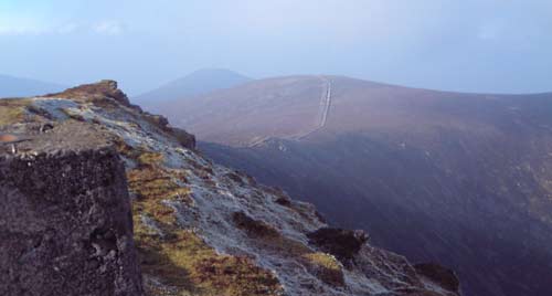
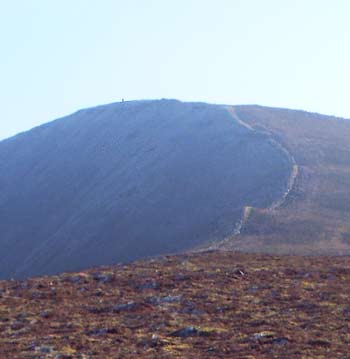
Fifty years on from that first visit I returned once again on 13th November to do a solo night climb. I set off from the The Vee carpark at 4:22 a.m. and ascended the Sugarloaf keeping close to the wall on the way up. The sky was mostly clear and bejeweled with stars. I stopped regularly and turned off my headtorch to take in the spectacle.

The headtorch, incidentally, is a powerful 900 lumens Petzl Swift RL. This was a recent purchase and was the prompt for me to do the night climb - I was curious to see how it would perform. It is astonishingly bright at full power - I was reluctant to aim it at the sky in case I might blind the people on the International Space Station should it happen to be passing overhead. I never needed that much illumination: a lower setting did the job just fine. Highly recommended.

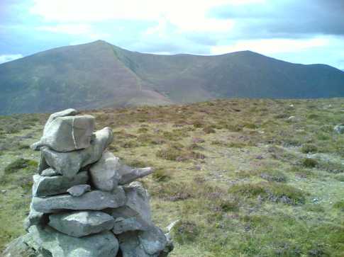
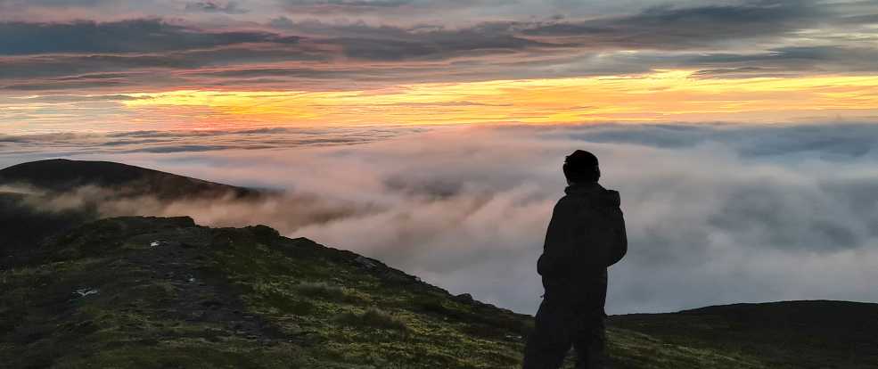
After reaching the summit of Sugarloaf I followed the wall along the ridge until I came to the trig point on Knockmealdown. The south-eastern sky was brightening but sunrise was still an hour and a half away. I spent the interim exulting in the views, taking some photos and video with my phone, GoPro and drone. It was still too dark to expect technically good results from that equipment but I had deliberately left my more capable DSLR gear at home in order to save weight.

As sunrise approached cloud began rolling in and soon the summit was enveloped in fog. I began to retrace my steps, knowing that keeping near to the ridge wall would get me back to my starting point. This meant going via the summit of Sugarloaf whereas normally, in good visibility, I would veer across its flank to avoid ascending it. That additional ascent is relatively minor however and it was safer to do it now that thick fog enveloped the mountain.

At the Sugarloaf summit the wall veers west and down and after 30 minutes or so I was back at my car. Once again, Knockmealdown had afforded me an enormously satisfying experience. Linkback: mountainviews.ie/summit/45/comment/23349/
Read Less
Read More

            MountainViews.ie picture about Knockmealdown (<em>Cnoc Mhaoldomhnaigh</em>)
simon3 on Knockmealdown
by simon3 17 May 2003
Knockmealdown boasts two interpretations of the Irish origins of its name, either Cnoc Mhaoldomhnaigh Muldowneys' Hill or Cnoc Maol Donn bald brown hill. Leaving aside such literary argument, it is the tallest mountain in Waterford.

Our view from beside the trig pillar is towards the north west. Just left of centre on the skyline is Sugarloaf Hill, while nearer and at the right is the ridge leading to Knockmoylan (768m and unnamed on the OS).

Reputedly, buried at the summit in a place he himself chose is Mr. Henry Eeles, an author, with his dog and gun. We didn’t see any signs of interment on our visit. However, as you can see, there might well be a funeral if anyone ventured over the steep NE facing side of Knockmealdown. There is a drop of over 300m to two tiny lakes at about 480m Linkback: mountainviews.ie/summit/45/comment/498/
Read Less
Read More

Another county top!
by paulocon 28 Sep 2011
1st top of a short horseshoe walk on the Knockmealdowns on 14/09/2011. Started at the Glennandaree Bridge from which the going is relatively easy. Some heather needs to be encountered on the lower stretches of the mountain but this gives way as you gain height to rockier ground. The summit is marked by a trig pillar from which the ground to the North falls dramatically so care is needed in low visibility. Superb views encompassing the Knockmealdown Range as well as the Comeraghs, Galtees and solitary Slievenamon. Further away is the South coast and the Celtic Sea. A handy walk to gain the top of Waterford. Continued onto Knockmoylan and then Sugarloaf Hill. Done a write-up of the walk at: http://climbingirelandsmountains.blogspot.com/2011/09/evening-in-knocmealdowns.html Linkback: mountainviews.ie/summit/45/comment/6541/
Read Less
Read More

            MountainViews.ie picture about Knockmealdown (<em>Cnoc Mhaoldomhnaigh</em>)
simon3 on Knockmealdown
by simon3 17 May 2003
Robert Lloyd Praeger [The Way That I Went 1969] wasn’t wholly impressed by the Knockmealdowns. He said “.. forms a fine upstanding row of peaks, rising to 2609 feet: but this is merely clever window dressing. There is nothing except this single row of summits – no lakes or corries or deep glens or cliffs; very little bare rock: and so, while they furnish fine walking, the zoologist or botanist will find these hills somewhat monotonous.” We can certainly agree about the walking which gives great views and a succession of relatively unfrequented hills.

This view of Knockmealdown was taken one fine day in February en-route to Knockmoylan. Linkback: mountainviews.ie/summit/45/comment/499/
Read Less
Read More

David Bell on Knockmealdown
by David Bell 16 Jun 2003
Climbed the Sugarloaf mountain-Knockmoylan-Knockmealdown we took our time 5 hrs in all , beautiful day .
Re Simon3 about grave of Mr Henry Eeles , we found a possible grave on the SE slope of Knockmealdown. A large unmarked slab about 200 metres from the summit.
The mountains offered a challenging walk for a beginner and provided fantastic views south and north. Walk along the ridge to Knockmealdown from Sugarloaf was rugged to start but the boundary wall provides a good walk way to make the journey slightly easier. Linkback: mountainviews.ie/summit/45/comment/550/
Read Less
Read More
EDIT Point of Interest
text
Videos
(none available)
Recent Contributions
x
Conditions and Info
Use of MountainViews is governed by conditions and a privacy policy.
Read general information about the site.
Opinions in material here are not necessarily endorsed by MountainViews.
Hillwalking is a risk sport. Information in comments, walks, shared GPS tracks or about starting places may not be accurate for example as regards safety or access permission. You are responsible for your safety and your permission to walk.
See the credits and list definitions.

OSi logo
OSNI/LPS logo
Open Street Map
(Various variations used.)
British summit data courtesy:
Database of British & Irish Hills