Members and Supporters, the MountainViews Committee requests your help to meet the costs of the website and of other activities such as insured events or publications.
MacGillycuddy's ReeksArea, Cen: Reeks West
Subarea
Feature count in area: 29, all in Kerry,
OSI/LPS Maps: 78, EW-KNP, EW-R
Highest Place: Carrauntoohil 1038.6m
Starting Places (19) in area MacGillycuddy's Reeks: Ballaghbeama Gap, Bridia Valley End, Cronins Yard, Gap of Dunloe Head of, Gap of Dunloe Kate K, Glashaknockbrassel Stream, Glasheenoultagh Stream, Hydro Road CP, Knocknsallagh Bridge, Lisleibane Trail Head, Lough Acoose North, Lough Acoose West, Lough Cappanlea OEC, Lough Caragh SW, Lough Fada N, Lough Reagh N, Maghanlawaun Bridia Valley, Shamrock Farmhouse B&B, Tomies Lough Leane NW
Summits & other features in area MacGillycuddy's Reeks: Cen: Reeks West: Beenkeragh 1008.2m, Caher 1000m, Caher West Top 973.4m, Carrauntoohil 1038.6m, Cnoc Íochtair 746.3m, Hag's Tooth 662m, Knockbrinnea East Top 845.4m, Knockbrinnea West Top 852.2m, The Bones Peak 956.5m, Skregmore 847.7m, Stumpa Bharr na hAbhann 852.1m E: Cnoc an Bhráca: Cnoc an Bhráca 728m, Cnoc na dTarbh 655m, Strickeen 440m N: Reeks North: Knockbrack 425m, Knocknabrone Hill 353m, Skregbeg 573m NW: Gortnagan: Gortnagan Beg 298m SE: Reeks East: Brassel Mountain 575m, Cnoc an Chuillinn 954.6m, Cnoc an Chuillinn East Top 922.9m, Knocknapeasta 985.1m, Cnoc na Toinne 844.1m, Cruach Mhór 930.8m, Maolán Buí 968.9m, The Big Gun 939.9m SW: Bridia: Beann Bhán 459.5m, Beendarrig 449.7m, Beann Dubh 450.5m
Note: this list of places may include island features such as summits, but not
islands as such.
Knockbrinnea East Top, 845.4mMountain Cnoc Broinne (mullach thoir) A name in Irish,
Place Rating ..
(Ir. Cnoc Broinne [TH], 'hill of the breast'), Kerry County in Munster province, in Arderin Beg, Vandeleur-Lynam Lists, Knockbrinnea East Top is the 22nd highest place in Ireland.
Grid Reference V81025 85735,
OS 1:50k mapsheet 78 Place visited by: 270members, recently by: kelleher, simon3, rhw, maoris, Carolineswalsh, knightsonhikes, ToughSoles, conorjob, abeach, Krzysztof_K, derekfanning, osullivanm, Gergrylls, overthehill67, jackos
I visited this place: NO (You need to be a logged-in member for this.)
Longitude: -9.733511, Latitude: 52.011396, Easting: 81026, Northing: 85735,
Prominence: 21.2m, Isolation: 0.3km ITM: 481001 585794 Bedrock type: Well-bedded grey sandstone, (Lough Acoose Sandstone Formation) Notes on name: Knockbrinnea is a shoulder of Beenkeragh overlooking the Hag's Glen.
Short or GPS IDs, 6 char: KnckEs, 10 char: KnckbrEstT Linkback: https://mountainviews.ie/summit/22/
Gallery for Knockbrinnea East Top (Cnoc Broinne (mullach thoir)) and surrounds
Summary
for Knockbrinnea East Top (Cnoc Broinne (mullach thoir)):
Smaller Twin
Summary created by Colin Murphy, march-fixer
2015-05-25 16:35:24
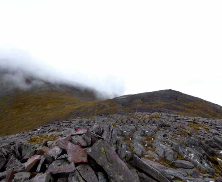
Picture: Summit with West top visible 400M away.
A rocky twin top with Knockbrinnea (W), this nice vantage point provides fantastic views north and north east over a wide agricultural hinterland. It is an also excellent vantage point for views into the Hag's Glen. It is easily reached along a sloping ridge from the handy car-park at Lisleibane Lilybane (V82714 87307).
An alternative starting point is Cronin's Carpark at Cronins (V83600 87300). Proceed along the track into the Hag's Glen until the bridge crosses the river at A (V826 864). From here proceed directly up the slope to the west. Terrain is mostly grass at first and firm underfoot and initially slope is reasonably gentle, but becomes very steep after about 400M altitude and remains so pretty much to the summit, which is a large rocky area topped by a cairn. 1 hour 15 minuted from car to summit.
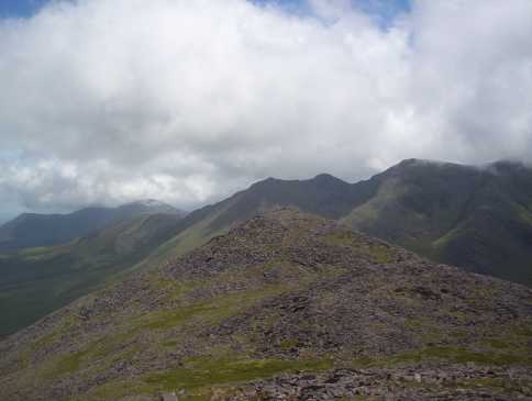
Picture: Knockbrinnea East Top with northern part of Reeks Ridge behind from Knockbrinnea West Top
eflanaga on Knockbrinnea East Top
by eflanaga
18 Jul 2006
From the summit of Beenkeeragh IB (V80125 85246) (see for previous stage of walk) it is a short but fairly steep drop onto the wide col dividing it from the twin peaks of Knockbrinnea. Once on the flat col the ground is much easier to negotiate and if you make for the East top of Knockbrinnea first you can avoid much of the rockier walking until you approach that summit. On my way down I noticed a large number of sheep who appeared somewhat depressed looking. I was unsure what might have been the cause of their malady until I notice that each was adorned with red, white and blue paint daubed on their coats. Obviously, French supporters depressed at their misfortune in the World Cup Final just a few days previously – Zidane’s unfortunate faux pas had obviously added to the feelings of misery they so clearly exhibited as I passed them by. The walk across the col to the east top passing underneath the West top (which I would bag on the return) was a welcome respite from the rocky underfoot conditions experienced since summiting Caher West Top, but it was to be short lived as the ground again turns rocky as you meet the obvious track running below both summits. The top of Knockbrinnea IC (V81020 85737), with its small cairn is unremarkable in itself, but the views around it are excellent not least that down into the Hags Glen and across to Carrauntoohill’s Northern aspect. There were three walkers on the summit of the highest peak who enthusiastically returned my wave as I made my way from the summit to take a fairly short walk over to its sister top to the west (see for next stage of walk). Linkback: mountainviews.ie/summit/22/comment/2433/
Read Less
Read More
Dan on Knockbrinnea East Top
by Dan
1 Sep 2004
Climbed Knockbrinnea east and west as part of a day long hike taking in Beenkeragh, Carrauntoohil and Caher. Left our campsite beside Lough Callee and started the climb from near the outlet of Lough Gouragh. Its quite a steep and long climb to the top from here. It doesn’t present any major obstacles, its just a bit of an endurance test really, being a long and steady climb. The view back toward Stoompenaduff and Carrauntoohil is great though and on the other side a great view out toward Dingle Bay. Once you’ve reached this summit most of the hard work climbing Beenkeragh has already been done. Linkback: mountainviews.ie/summit/22/comment/1157/
Read Less
Read More
Picture: Knockbrinnea on the right of the Hag's Glen, with Carrauntoohil looming behind
murphysw on Knockbrinnea East Top
by murphysw
28 Jul 2005
On our way down from Beenkeragh we went around the shoulder of Knockbrinnea (W) without summiting it (due to tiredness probably!) but we did get to its lower eastern summit to get our bearings. The views here are stunning. Your fellow hikers look like dust mites on the path down in the Hag's Glen path and you get a great panorama of the Reek's Ridge too. A great plus for this mountain is its wilderness factor. After the veritable M50 that is Carrauntoohil we didn't meet a single soul on Knockbrinnea. The downside is that its side is heavily boulder strewn and you are always careful not to wrench an ankle. We rejoined the Hag's Glen from a gully beside the Hag's Tooth. Linkback: mountainviews.ie/summit/22/comment/1840/
Read Less
Read More
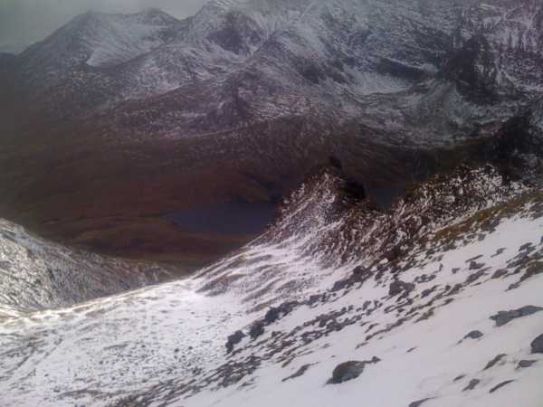
Picture: The Reeks in all their winter glory.
sbender on Knockbrinnea East Top
by sbender
12 Sep 2009
Looking down into the Hags glen along the Beenkeragh ridge after a fantastic climb that started at D (V820 855) keeping the Hags Teeth to the left. The snow, which started at approx 400m, was very deep at places. So it was on with the crampons an got the ice ax out. It was a very hard climb under these circumstances. Temperature on the summit was around -10 with a gale blowing, so I won't even try to guess what the wind chill added to this. On the way down I visited Stumpa an tSiamh (I think its called Coomcallee on OSi 78) which was a hard scramble to get up on and descent off again. When I arrived back in Glenbeigh, I heard there was a person gone missing that day on the other side of the ridge!!! Makes you think....and plan carefully Linkback: mountainviews.ie/summit/22/comment/4087/
Use of MountainViews is governed by conditions and a privacy policy.
Read general information about the site. Opinions in material here are not necessarily endorsed by MountainViews.
Hillwalking is a risk sport. Information in comments, walks, shared GPS tracks or about starting places may
not be accurate for example as regards safety or access permission. You are responsible for your safety and your permission to walk.
See the credits and list definitions.


 Our Facebook page.