Members and Supporters, the MountainViews Committee requests your help to meet the costs of the website and of other activities such as insured events or publications.
Feature count in area: 29, all in Kerry,
OSI/LPS Maps: 78, EW-KNP, EW-R
Highest Place: Carrauntoohil 1038.6m
Starting Places (19) in area MacGillycuddy's Reeks: Ballaghbeama Gap, Bridia Valley End, Cronins Yard, Gap of Dunloe Head of, Gap of Dunloe Kate K, Glashaknockbrassel Stream, Glasheenoultagh Stream, Hydro Road CP, Knocknsallagh Bridge, Lisleibane Trail Head, Lough Acoose North, Lough Acoose West, Lough Cappanlea OEC, Lough Caragh SW, Lough Fada N, Lough Reagh N, Maghanlawaun Bridia Valley, Shamrock Farmhouse B&B, Tomies Lough Leane NW
Summits & other features in area MacGillycuddy's Reeks: Cen: Reeks West: Beenkeragh 1008.2m, Caher 1000m, Caher West Top 973.4m, Carrauntoohil 1038.6m, Cnoc Íochtair 746.3m, Hag's Tooth 662m, Knockbrinnea East Top 845.4m, Knockbrinnea West Top 852.2m, The Bones Peak 956.5m, Skregmore 847.7m, Stumpa Bharr na hAbhann 852.1m E: Cnoc an Bhráca: Cnoc an Bhráca 728m, Cnoc na dTarbh 655m, Strickeen 440m N: Reeks North: Knockbrack 425m, Knocknabrone Hill 353m, Skregbeg 573m NW: Gortnagan: Gortnagan Beg 298m SE: Reeks East: Brassel Mountain 575m, Cnoc an Chuillinn 954.6m, Cnoc an Chuillinn East Top 922.9m, Knocknapeasta 985.1m, Cnoc na Toinne 844.1m, Cruach Mhór 930.8m, Maolán Buí 968.9m, The Big Gun 939.9m SW: Bridia: Beann Bhán 459.5m, Beendarrig 449.7m, Beann Dubh 450.5m
Note: this list of places may include island features such as summits, but not
islands as such.
Knocknapeasta, 985.1mMountain Cnoc na Péiste A name in Irish,
Place Rating ..
(Ir. Cnoc na Péiste [OSI 1:25,000], 'hill of the serpent/monster'), Com Cíoch, Kerry County in Munster province, in Arderin, Vandeleur-Lynam, Irish Best Hundred, Irish Highest Hundred, Irish 900s Lists, Cnoc na Péiste is the 4th highest place in Ireland.
Grid Reference V83600 84200,
OS 1:50k mapsheet 78 Place visited by: 635members, recently by: rhw, MartMc, orlaithfitz, maoris, Magic, Carolineswalsh, ToughSoles, muddypaws, Sonyalaw, Enda66, abeach, Lucy.boland, DeirdreM, chelman7, Krzysztof_K
I visited this place: NO (You need to be a logged-in member for this.)
Longitude: -9.695516, Latitude: 51.998151, Easting: 83600, Northing: 84200,
Prominence: 253m, Isolation: 0.5km ITM: 483575 584259 Bedrock type: Well-bedded grey sandstone, (Lough Acoose Sandstone Formation) Notes on name: The lake below this peak is Loch Coimín Piast, 'lake of the little hollow of serpents'. Like many another Irish mountain lake, there was probably a story of a water-monster associated with it which has now been lost. In December 1943 an American Dakota aircraft crashed into the slopes of Cnoc na Péiste just above the lake. Pieces of the aircraft are still visible. A plaque here commemorates the 5 victims and there is another plaque at Cronin's Yard (Jim Ryan, Carrauntoohil and MacGillycuddy's Reeks, 80-81).
Short or GPS IDs, 6 char: Kncknp, 10 char: Kncknpst Linkback: https://mountainviews.ie/summit/4/
Gallery for Knocknapeasta (Cnoc na Péiste) and surrounds
Summary
for Knocknapeasta (Cnoc na Péiste):
A magnificent rocky peak - the highest of the Eastern Reeks.
Summary created by markmjcampion, jackill
2023-08-16 16:24:17
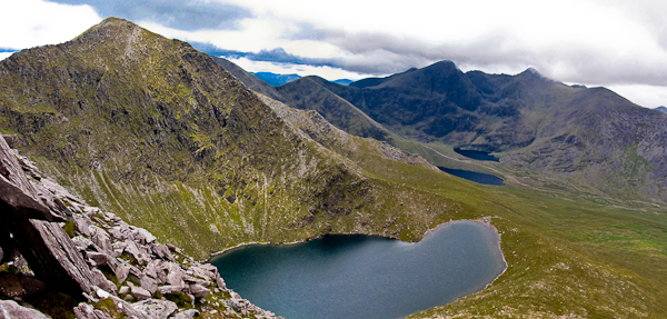
Picture: Knocknapeasta from Cruach Mhor
Knocknapeasta lies high above the Hag's Glen to the N and the Black Valley to the S. It's conical, rocky summit is the end point of the most challenging ridge walk in the country. However, access from other directions is easier. Great views esp. of the Big Gun, Carrauntoohil, Purple and indeed much of Corca Dhuibhne and Beara can be visible.
N. Park at Cronin's Yard Cronins (V83608 87337) or Lisleibane Lilybane (V82707 87311) and follow the obvious track towards Hag's Glen. You've a few choices from here :
a) to avoid the challenge of the arête head into the glen as far as approx. A (V82303 85034) and from here head SE up The Bone. The route is fairly obvious and as you ascend it becomes narrower and the track more obvious. If taking this route down be very careful to keep right at around B (V83100 83899).
b) leave the track at approx. C (V83047 86583) and head for Loch Cummeenapeasta. If you care to take on The Big Gun go E at the lake and head steeply up a huge boulder field [rock hopping is easier than finding a way around] to the summit of Cruach Mór. See comments on CM and TBG for more details. 3 to 4 hours.
If you'd prefer to avoid the arête go to the right side of the lake and ascend the equally steep NW spur of K. 2.5hrs +
SE Park with care near Shamrock BB (V85642 82670) E and strike out NW up a long, well-defined spur to Feabrahy. Expect steeper ground thereafter - a slog will take you to the col to the SW of the summit. Allow 2hrs+
Notable tracks incl. track/4190. track/3529 and track/3790.
I climbed the Cruach Mhor to Cnoc an Chullin ridge, and back to Maolan Bui for descent down the Bone, on a misty 10 December 2004. Occasional glimpses of views into the corries, but just before descending a superb cloud inversion, with the summits of the main peaks above the cloud and a fantastic brokenspectre.
Cruach Mhor to Cnoc na Peiste is an excellent ridge which deserves much more attention from UK walkers. In terms of length, interest and difficulty, it is better than anything in England and Wales. Only Snowdon via Crib Goch is at all comparable. There is more massive exposure on Crib Goch, but few, if any, scrambling moves are needed on Crib Goch This ridge is more scrambly.
In Scottish terms, An Teallach via Corrag Bhuidhe Buttress is definitely harder, and probably Aonach Eagach in my view. It is most similar to Am Fasarinen on Liathach, though again there is more exposure and a bit less scrambling moves on the Liathach ridge. I agree with a previous comment that this ridge is a UK grade 2 scramble. But overall superb.
Just one final comment. On a wettish day after some wet days, I found both the rocks and grass on the steep descent down the Bone pretty treacherous, requiring concentration. It is certainly not a fast descent in these conditions. Linkback: mountainviews.ie/summit/4/comment/1364/
Read Less
Read More
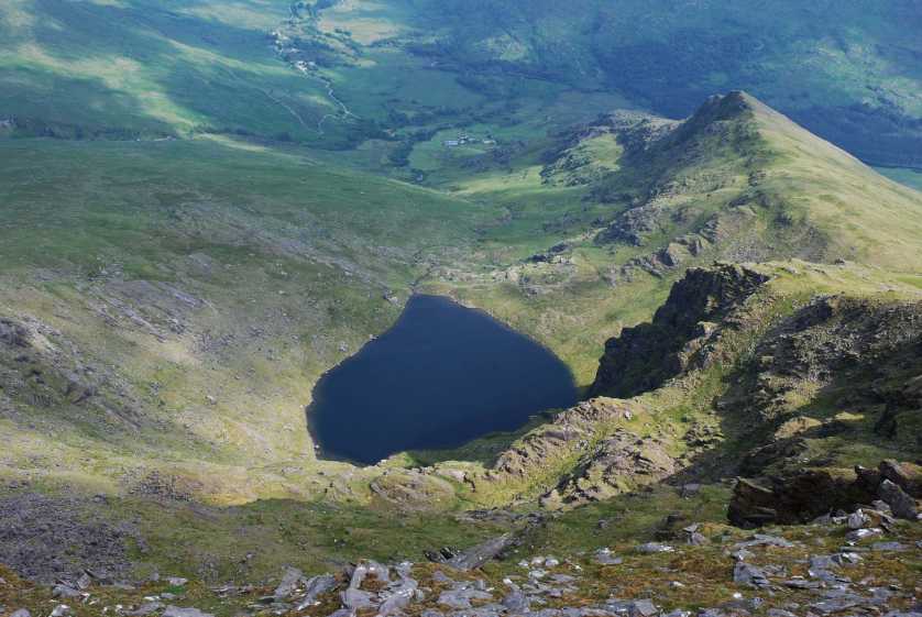
Picture: Lough Googh from Cnoc na Péiste
Ascent from the Black Valley
by Wildcat
31 Aug 2013
I set off from the Black Valley hostel but, after a grim start on rough land with bracken higher than myself in places, I reached an insurmountable fence and had to return to the road. Although feeling more like the Australian Outback then the wilds of Kerry in temperatures over 30 degrees C, I followed the Black Valley road as far as Shamrock Farmhouse B&B, where I got permission to go through fields en route to Lough Googh.
A pleasant walk on short grass took me through several gates then good easy ground (but without a path) led to an easily-negotiated area of broken slabs and outcrops above 400m. I stopped for a break at Lough Googh, overlooked by beetling crags to the west. From there, easy grass flanks took me upwards (to the south-west), with a short path on the steepest section. Once on the ridge connecting Feabrahy and Cnoc na Péiste (at 600m), I continued north-west on fairly steep slopes with scattered rocks. Above 850m, I slanted leftwards, steeply uphill, to reach the col between Maolán Buí and Cnoc na Péiste, then a good path took me along the broad easy-angled ridge to the summit - 24 degrees C in the shade and nobody in sight. Views were a little hazy but the intimidating-looking ridge to An Gunna Mór looked sharp enough!
I returned to the hostel the same way although, with more time and less heat, a circular route over An Gunna Mór, Cruach Mhór and descending by the Derrycarna River would make a fine walk. Linkback: mountainviews.ie/summit/4/comment/15167/
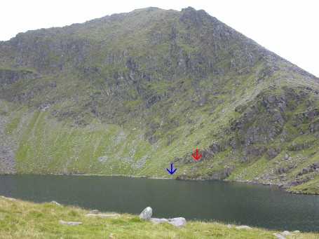
Cnoc na Péiste from the shore of the lake. Blue arrow indicates the location of a blue rope which is tied to the wing in the water (and to a rock on the other end). No use pulling it: the wing is too heavy. The red arrow shows the location of a memorial plate. The plane crashed into the mountain 500 feet above this plate. Linkback: mountainviews.ie/summit/4/comment/1904/
Read Less
Read More
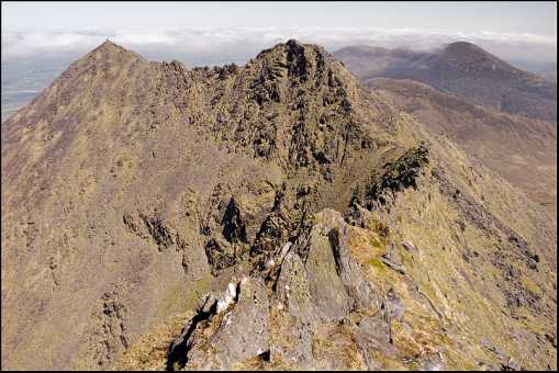
jackill on Knocknapeasta
by jackill
29 Aug 2004
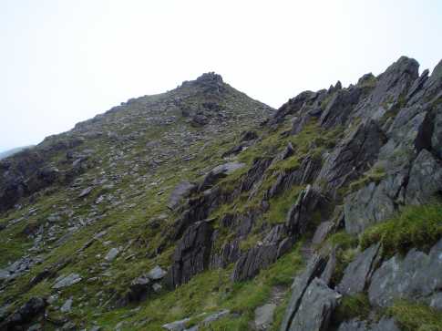
Cnoc na Péiste from the ridge after The Big Gun. The path after the col under the Big Gun starts on the south side then crosses over to the north side then back to the south side - the only hair raising bit is on the north side - a two foot ledge in places with nothing between you and Lough Cummeenapeasta except fresh air. Linkback: mountainviews.ie/summit/4/comment/1145/
Use of MountainViews is governed by conditions and a privacy policy.
Read general information about the site. Opinions in material here are not necessarily endorsed by MountainViews.
Hillwalking is a risk sport. Information in comments, walks, shared GPS tracks or about starting places may
not be accurate for example as regards safety or access permission. You are responsible for your safety and your permission to walk.
See the credits and list definitions.


 Our Facebook page.