Donation Request 2024
You do not have to be logged in to donate.
DONATE
Members and Supporters, the MountainViews Committee requests your help to meet the costs of the website and of other activities such as insured events or publications.You do not have to be logged in to donate.
Welcome to MountainViews
If you want to use the website often please enrol (quick and free) at top right.
A small change needed. The page you went to with a url that has mountainviews.ie/mv/index.php is now superceded by the url at the top. Use this new form of url in future. Change any shortcuts or bookmarks you may have for the old format.
Overview
For more map options click on any overview map area or any detail map feature.
Detail Map Features
Showing 20 of a total of 43 items:
Carrauntoohil 1038.6m, Beenkeragh 1008.2m, Caher 1000m, Caher West Top 973.4m, Maolán Buí 968.9m, The Bones Peak 956.5m, Cnoc an Chuillinn 954.6m, Cnoc an Chuillinn East Top 922.9m, Knockbrinnea West Top 852.2m, Stumpa Bharr na hAbhann 852.1m,
4395, 23km
2580, 19km
4190, 17km
4683, 15km
2304, 15km
2131, 15km
2390, 14km
1532, 13km
2841, 13km
4684, 12km
Carrauntoohil 1038.6m, Beenkeragh 1008.2m, Caher 1000m, Caher West Top 973.4m, Maolán Buí 968.9m, The Bones Peak 956.5m, Cnoc an Chuillinn 954.6m, Cnoc an Chuillinn East Top 922.9m, Knockbrinnea West Top 852.2m, Stumpa Bharr na hAbhann 852.1m,
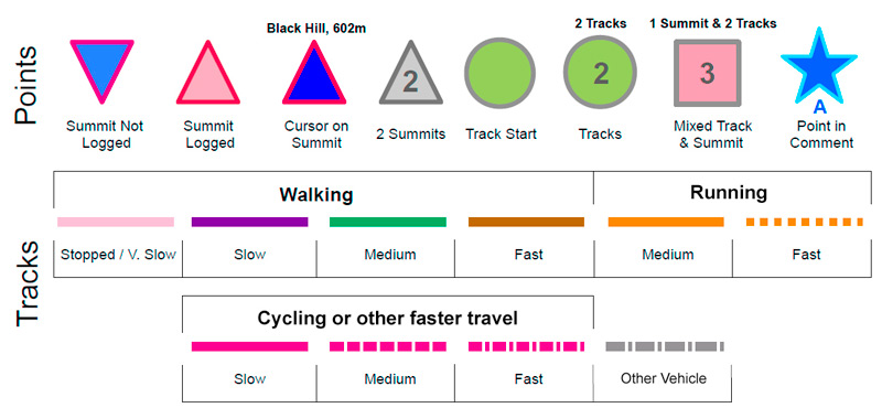
Tracks:
Find Suggested Walks
Find hill, mountain, island, coastal feature.
Videos


Recent Contributions
 Get Notifications
Get Notifications
Lake District: Dale Head Horseshoe
Crocknasharragh: Impressive views on nitial ascent.
 Colin Murphy
Crocknasharragh: Fine views on ascent
 Colin Murphy
Lake District: Coledale Horseshoe
Cunnigar: Short trek to summit
 Fergalh
Longish walk to isolated top
 Colin Murphy
Westtown Hill: Tramore's Highest Point
 DeirdreM
Knockbrinnea West Top: Eflanagan on the Knockbrinneas
 eflanaga
Ascending the Knockbrinneas from the north.
 simon3
Knockbrinnea West Top: Larger Twin
 Collaborative entry
Lobawn Loop - Clockwise avoids any steep ascent! Easy stream crossing.
Knockaunanattin West Top: Views, loughs and a navigational aid.
 simon3
Conditions and Info
Use of MountainViews is governed by conditions and a privacy policy.
Read general information about the site.
Opinions in material here are not necessarily endorsed by MountainViews.
Hillwalking is a risk sport. Information in comments, walks, shared GPS tracks or about starting places may not be accurate for example as regards safety or access permission. You are responsible for your safety and your permission to walk.
See the credits and list definitions.
 Visit our Facebook page.
Video display
MacGillycuddy's Reeks
Area Cen: Reeks West Subarea
Place count in area: 29,
OSI/LPS Maps: 78, EW-KNP, EW-R
Highest place: Carrauntoohil, 1038.6m
Maximum height for area: 1038.6 metres,
Maximum prominence for area: 1038.6 metres,
Places in area MacGillycuddy's Reeks:
Cen: Reeks West:Beenkeragh 1008.2mCaher 1000mCaher West Top 973.4mCarrauntoohil 1038.6mCnoc Íochtair 746.3mHag's Tooth 662mKnockbrinnea East Top 845.4mKnockbrinnea West Top 852.2mThe Bones Peak 956.5mSkregmore 847.7mStumpa Bharr na hAbhann 852.1m
E: Cnoc an Bhráca:Cnoc an Bhráca 728mCnoc na dTarbh 655mStrickeen 440m
N: Reeks North:Knockbrack 425mKnocknabrone Hill 353mSkregbeg 573m
NW: Gortnagan:Gortnagan Beg 298m
SE: Reeks East:Brassel Mountain 575mCnoc an Chuillinn 954.6mCnoc an Chuillinn East Top 922.9mKnocknapeasta 985.1mCnoc na Toinne 844.1mCruach Mhór 930.8mMaolán Buí 968.9mThe Big Gun 939.9m
SW: Bridia:Beann Bhán 459.5mBeendarrig 449.7mBeann Dubh 450.5m
Note: this list of places includes island features such as summits, but not islands as such.
Highest place:
Carrauntoohil, 1038.6mPlaces in area MacGillycuddy's Reeks:
Cen: Reeks West:
Beenkeragh 1008.2mCaher 1000mCaher West Top 973.4mCarrauntoohil 1038.6mCnoc Íochtair 746.3mHag's Tooth 662mKnockbrinnea East Top 845.4mKnockbrinnea West Top 852.2mThe Bones Peak 956.5mSkregmore 847.7mStumpa Bharr na hAbhann 852.1mE: Cnoc an Bhráca:
Cnoc an Bhráca 728mCnoc na dTarbh 655mStrickeen 440mN: Reeks North:
Knockbrack 425mKnocknabrone Hill 353mSkregbeg 573mNW: Gortnagan:
Gortnagan Beg 298mSE: Reeks East:
Brassel Mountain 575mCnoc an Chuillinn 954.6mCnoc an Chuillinn East Top 922.9mKnocknapeasta 985.1mCnoc na Toinne 844.1mCruach Mhór 930.8mMaolán Buí 968.9mThe Big Gun 939.9mSW: Bridia:
Beann Bhán 459.5mBeendarrig 449.7mBeann Dubh 450.5mNote: this list of places includes island features such as summits, but not islands as such.

Bedrock type: Purple sandstone & siltstone, (Ballinskelligs Sandstone Formation)
Just as the summit of Ireland's highest mountain is often covered in mist, its name is shrouded in uncertainty. Unlike some lesser peaks, such as Mangerton or Croagh Patrick, it is not mentioned in any surviving early Irish texts. P.W. Joyce suggests that meaning of this name is 'inverted reaping hook' and that this sense can be appreciated from the middle of the Hag's Glen. He proposes that the reaping hook is inverted in the sense that it is convex rather than concave [Irish Names of Places, vol. i, p. 6]. The serrated ridges which run up the north face of Carrauntoohil are certainly amongst its most distinctive features and are therefore likely to have given name to the mountain. However, the image of a 'convex reaping-hook' is a very odd and complex one on which to base a place-name, and the use of tuathal to mean inverted, while found in dictionaries, seems to be without parallel in other Irish place-names. It seems more likely that the second element is simply the personal name 'Tuathal' as John O'Donovan believed. This forename was common in Medieval Ireland and is the basis of the surname Ó Tuathail (O'Toole). It also occurs in Lios Tuathail (Listowel, Co. Kerry) and Carraig Thuathail (Carrigtwohill, Co. Cork), which the Flanagans interpret in both cases as a personal name (Irish Place Names). Intriguigingly, one of the earliest accounts to mention Ireland's highest mountain, written by Isaac Weld in 1812, refers to it as 'Gheraun-tuel', which suggests that the first element was not corrán, but rather géarán, 'fang', which is found in the name of several other Kerry mountains. On the basis of this one reference, it is difficult to say whether this represents an earlier form of the name or whether it was a corruption. For further information on the name, see Paul Tempan, Some Notes on the Names of Six Kerry Mountains, JKAHS, ser. 2, vol. v (2005), 5-19. Carrauntoohil is the highest mountain in Ireland. Carrauntoohil is the highest point in county Kerry.
Linkback: https://mountainviews.ie/summit/1/
COMMENTS for Carrauntoohil (Corrán Tuathail) 1 2 3 4 5 .. 20 Next page >>  Follow this place's comments

|
|
|
|
||
| MountainViews.ie, a Hill-walking Website for the island of Ireland. 2400 Summiteers, 1480 Contributors, maintainer of lists: Arderins, Vandeleur-Lynams, Highest Hundred, County Highpoints etc | |||